Mauricio Gonzalez studied Marine Biology in Colombia South America and worked on coral reef community ecology for 3 years before becoming a teacher in the NYC public school system. Because of his background, he understood the vital role of applied research in conservation. However, he’s also come to understand that research performed within the confines of exclusive institutions is limited in what it can accomplish. Therefore, to address the problems of environmental degradation he sought to expose underrepresented youth to STEM programs that he has created such the Schwartz Science and Urban Ecology programs in Harlem and the Marine Biology Research and Harbor SEALS programs on Governors Island. His programs have aimed to support and develop youth’s curiosity in the natural sciences through project formulation, management, and execution. By directly including our youth in the research process, science and it’s applications will have a far wider reach and make more meaningful contributions to our planet and, thus, to society.
You’re cordially invited to attend our 5th Annual Marine Science Symposium at the New York Harbor School on May 18 starting at 12pm. Experience cutting edge science from our very own Marine Biology Research Scholars and our special guest Mr. Charlie Fitzpatrick, ESRI Schools Program Manager. Mr. Fitzpatrick will be sharing his journey through the exciting world of Geospatial technology. Also presenting are this year’s NYC Science and Engineering Fair participants and finalists including Cezanne Bies and Zain Bin Khalid who received the third award among NYC’s top science scholars for their project on oyster restoration. Go New York Harbor School science!
It’s not often that a young scholar passes through the public school system in New York with all the qualities of a true scientist: organized yet willing to take risks, diligent yet creative, attentive to detail yet an eye on the big picture, and, most importantly, not deterred by set-backs. Remarkable is the word that comes to mind when reviewing all of Cézanne Bies’, class of ’16, accomplishments and attributes in the past three years at the Marine Biology Research Program (MBRP). Cézanne was a finalist in the 2016 NYC Science and Engineering Fair together with her project partner Zain Bin Khalid for their project Survival and Growth Performance of Crassostrea virginica in the NYC Harbor, the first scholar to earn 12 SUNY college credits for science research at the New York Harbor School (NYHS), and helped to launch the marine genetics program there too, just to name a few.
Cézanne Bies teaching her phys-chem team how to perform the Winkler Method to measure the dissolved oxygen of the Harlem River.
Whether collecting physical-chemistry samples from the Hudson River Estuary, planting eel grass at Bush Terminal Piers park, organizing and analyzing Harbor SEALs project data, or extracting oyster DNA, Cézanne is always at the center of the action. Cézanne’s dedication and leadership has truly elevated the level of science at the NYHS and particularly the MBRP.
Cézanne Bies extracting eastern oyster DNA to test for genetic differences between farmed and wild oysters.
Early on in the 10th grade, Cézanne showed great promise as a budding scientist by constructing the 1st place winning wind racer with project partner Raphael Bonnano and in the 11th grade Cézanne won 1st place with the project Determining the Genetic Difference between Farmed and Wild Oysters. Cézanne’s unique curiosity and problem solving skills have been essential to running the Marine Science lab.
Cézanne Bies and Orlando Ramos planting eel grass at Bush Terminal Piers Park, Brooklyn.
Aside from these accomplishments, Cézanne is a frequent contributor to the school newspaper, The Harbor Current, an intern with Earth Matter organizing the NYHS biomass production to create compost, an integral member of the Gay-Straight Alliance, and an editor of the NYHS year book. Cezanne intends to pursue a degree in marine restoration genetics. We wish Cézanne all the best in the years to come.
Cézanne Bies and Zain Khalid in the 2016 NYCSEF competition. They were recognized by NOAA and the RICOH Company for the best project in ocean sustainability and restoration science.
Compost tea prepared by Intermediate Marine Research scholar Cindy Isidoro, class of ’17.
Cindy Isidoro, Intermediate Marine Research scholar, has begun executing an experiment to test for the effects of various natural/organic fertilizers on the health of radish plants. One of her treatments is compost tea, a brewed mixture created with compost from food scraps at the New York Harbor School and live water from the recirculating aquaculture systems in the Marine Science lab where we grow Tilapia. Cindy will compare the performance of the plants with this tea, plain compost, and plain soil, among other treatments. This project is critical in order to understand new agricultural technologies that address food and environmental justice. As organic products are increasingly sought after to avoid agro-business’ questionable food safety practices and environmental degradation caused by over fertilization with industrial chemicals, compost tea may be a solution for a better planet and healthier lives. Stay tuned for her results! We’d like to thank our awesome project partners and Professional Advisory Committee members from Earth Matter, Infinitae Stockton, Marisa DeDominicis, and Andrea Lieske for all their support!
Cindy Isidoro, class of ’17.Cindy’s experimental set-up.
Team MBRP Cezanne Bies and Zain Bin Khalid swimming circles around NYC’s brightest on March 6’s NYC Science and Engineering Fair. (Photo credit: Ms. Woodhouse, MBRP mom)
This was a big week for Marine Biology Research Scholars. On March 6 four of our advanced marine research scholars presented at the NYC Science and Engineering Fair. Competing with over four hundred of the City’s brightest science scholars, Cezanne Bies, Zain Bin Khalid, Marc Jimenez, and Luca Goldmansour showcased their long term research projects to judges from NYC’s top research institutions.
Advanced marine science scholar Luca Goldmansour, class of ’16.Advanced marine science scholar Marc Jimenez, class of ’16.
On Friday, March 4th, four of our intermediate research scholars presented their research to their partners CIVITAS, the Hudson River Foundation, and the Environmental Defense Fund. Led by Melanie Smith (Project Manager) and team members Grace Carter (biodiversity team leader), Katha Conklin (plankton team leader), and Cindy Isidoro (benthos team leader) they successfully presented the project’s final Quality Assurance Project Plan for approval.
Left to right: Jameson Mitchell, Maura Smotrich, Cindy Isidoro, Katha Conklin, Grace Carter, Susan Maresca, Melanie Smith, Mauricio Gonzalez, Kate Boicourt, Jim Tripp. (Photo credit: Maura Smotrich, CIVITAS)
And finally, on Monday, February 29, the Department of Education’s Office of Post Secondary Readiness recognized our Professional Advisory Committee member Captain and Scientist Matthew Leahey from NGO Seasavers and the Coast Guard Auxiliary with a plaque of recognition for his outstanding support of the Harbor School and the Marine Biology Research Program specifically. Captain Leahey got our team started on monitoring plastics in the NY Harbor before any other organization on the City was doing so. He led the MBRP on multiple expeditions aboard his vessel, the Nomad. He also custom built a manta tow to perform the sampling at the Verrazano narrows. When not on the water, he was leading workshops at our lab on water resources, plastics contamination, and the difficulty of environmental measurements for monitoring. We’d like to thank all our Professional Advisory Committee members and partners for making all these accomplishments possible. And a special thank you goes out to Captain Leahey for his amazing dedication to our future scientists and our city at large. Go Harbor School Science!
Captain and Scientist Matthew Leahey with our Harbor scholars preparing for a plankton tow.
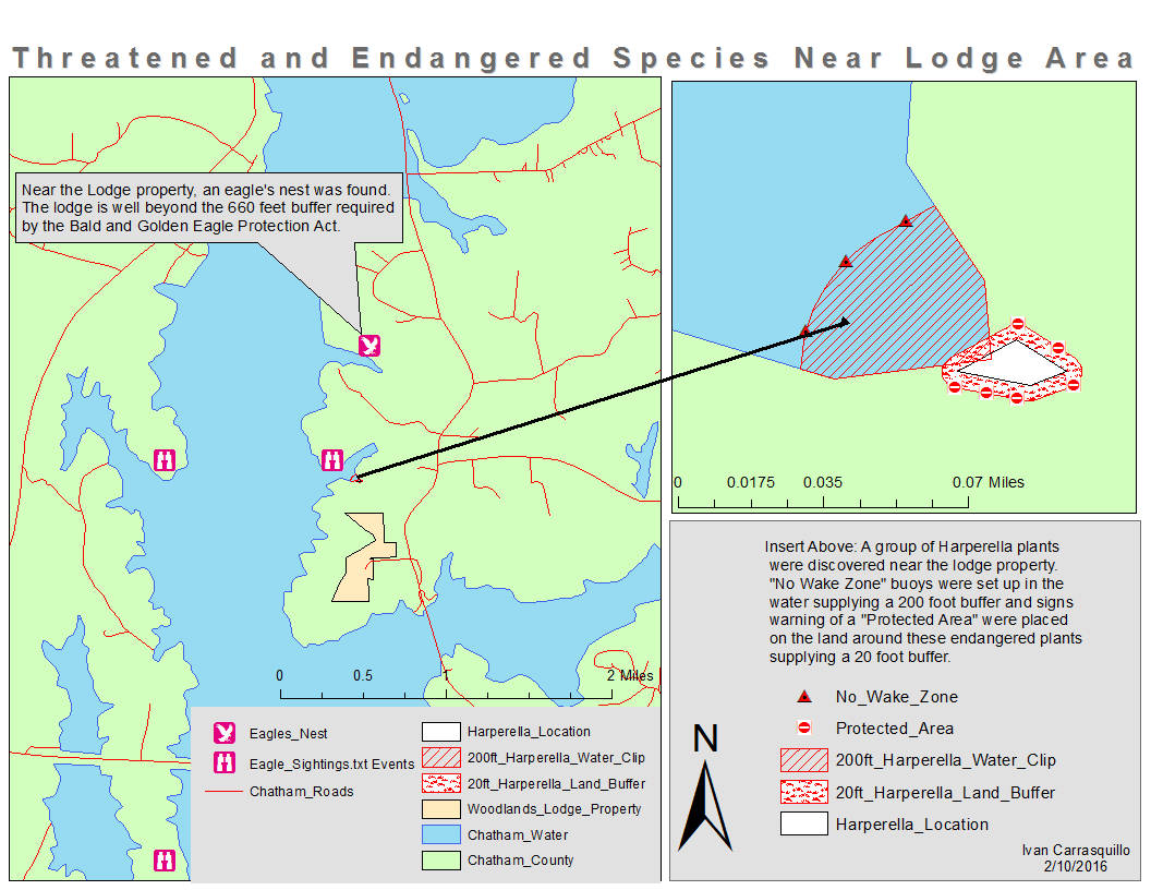
This map was completed by Ivan Carrasquillo, class of ’16, as part of the GIS curriculum of the Marine Biology Research Program.
Whenever the question “where” is asked Geographic Information Systems (GIS) are used to get the best answer. One of the major components of the Marine Biology Research Program is our GIS lab. Marine Biology Research scholars begin with introductory lessons on the importance of maps, the use of Global Positioning Systems for geo-referencing places & geocaching, and the differences between coordinate systems. Our scholars then begin implementing Digital Quest’s STEM aGIS curriculum of which the above map is one example. Our students are also required to begin a GIS project from scratch. We’ve had very diverse projects come out of our lab over the years ranging from Stop and Frisk to coastal land use. This year two of our scholars, Julia Montilla and Maria Giraldo are embarking on the Program’s first consulting project to map the American Chestnut trees that have been restored in Green-Wood cemetery and Prospect Park, NYC, by our Professional Advisory Committee (PAC) partner Bart Chezar and his team. We couldn’t have offered these wonderful opportunities if it wasn’t for the generous support of our PAC partner Jim Hall who has provided us with ArcGIS licenses over the years and the folks at ESRI, the makers of ArcGIS. It is important to note that ArcGIS is the industry standard software in GIS. We have been working to acquire the 2nd and 3rd parts of the curriculum in order to offer our scholars the possibility of obtaining Digital Quest’s GIS SPACE credential. The GIS field is a up-and-coming STEM field and a great 21st Century skill set for our scholars to add to their ePortfolios.
This map was created by Julia Montilla, class of 16, as part of an ESRI tutorial.
Marine Biology Research scholars Isabella Torres, Jared Vittore, and Seth Rivera, class of ’18, extracting DNA from their algae samples.
On February 6, 2016, a team of five Marine Biology Research scholars set out to sequence the genetic barcodes of marine organisms from the Hudson-Raritan Estuary in order to monitor its biodiversity. Part of our larger CIVITAS project (see previous post), these scholars have collected samples of algae and invertebrates from our Harlem River expeditions to create a baseline of what’s living there today. This type of work requires tedious pipetting, labeling on tiny vials, centrifuging, vortexing, and other crucial steps just to be able to extract the DNA from the organisms’ cells. During our next lab, these scholars will amplify the DNA and run it through a gel electrophoresis in order to prepare for genetic sequencing. The last step will be to identify the species using bioinformatics. You can see their research proposals here. A big thanks to our sponsor organization The Urban Barcode Project and Dr. Christine Marizzi from Cold Spring Harbor Lab for her and her team’s support.
Marine Biology Research scholars Zen Mena-Rodriguez and Nailea Rodriguez, class of ’18, extracting the gonads from their marine invertebrate samples.
Pierre Landet, senior genetic scientist mentor, and Nailea Rodriguez, beginner geneticist of the SEALS biodiversity team documenting a sample during our first East River Esplanade expedition of the NY Harbor SEALS/CIVITAS collaboration.
Yesterday the NY Harbor SEALS team, a citizen science after school program at the New York Harbor School and the consulting branch of the Marine Biology Research Program, embarked on it’s first of at least fourteen expeditions up the East River to characterize the marine habitat between 96 and 116 streets. The purpose of these expeditions is to determine the biodiversity and water quality at this site in order to propose a restoration strategy to local government agencies. Composed of four teams, the SEALS analyze sediment, plankton-plastics, physical-chemistry, and genetic biodiversity samples using professional instrumentation and techniques. We would like to thank our post-secondary and project partners Dr. Alberto Stolfi of NYU, Dr. Kathleen Nolan of St. Francis College, Dr. Michael Judge of Manhattan College, Maura Smotrich of CIVITAS, the Hudson River Foundation, the Department of Environmental Conservation, the Environmental Defense Fund, the New York Harbor Foundation, and the New York Harbor School for their ongoing commitment to our budding Marine Biology Research scholars. Go New York Harbor School marine science!
Harbor seal on a Governors Island dock in February, 2015. Credit: Ketelyn Fong, Class of 2015, NYHS.
On one cold afternoon in February during the harsh winter of 2014 a harbor seal climbed on to a dock at Governors Island, NYC. This top consumer of the food chain has now been spotted in several sites along Manhattan Island recently. These are critical events that indirectly or directly, depending on your point of view, reveal that our waters have steadily improved since the passing of the Clean Water Act in 1972. It’s also fitting that the seal revealed itself to us on the last year of our Harbor SEALs / EPA Citizen Science Water Quality Monitoring of the Lower Hudson River Estuary. As we close this important chapter of our work, harbor seal on dock, we’re preparing for our next big project. We’ll now be focusing on creating a baseline study and monitor the effects of different construction materials on the East River. This new project, in partnership with the East Side non-profit community group, CIVITAS, is being run to inform the reconstruction of the East River Esplanade and continue our efforts to restore the harbor seal’s habitat around NYC. Please find an opportunity to read our Final EPA Citizen Science Water Quality Report and visit our webpage. Here’s to the return of the harbor seal!
Harbor SEALs Citizen Science Team’s last sampling day of the Water Quality of the Lower Hudson River Estuary.
Andrew Sommer, class of ’15, presenting on enhancing biodiversity in the Hudson-Raritan Estuary using porcelain tiles. Photo Credit: Nelson Martinez, MBRP Parent
Greetings Marine Biology Research Program (MBRP) scholars, Professional Advisory Committee members, New York Harbor School Staff, Family, and Friends! Thank you again for helping to make the 4th Annual Harbor School Symposium a success. It was a real pleasure to see the team work, quality, and leadership that made the operation run as smoothly as it did on May 13th. Below is a list of highlights that are worth noting:
01) Parents volunteered to feed our hardworking scholars,
02) Parents and scholars worked together to manage the set up of tables and other vital logistics,
03) A team of parents and scholars managed all the judging,
04) School custodial staff set up the mess hall and made sure the building was looking beautiful,
05) School staff brought their classes to view the projects,
06) A student and a parent stepped up to pull the Symposium booklet together,
07) School administration attended the whole event, helped to judge, and opened up our ceremony,
08) The 12th grade judges helped to elevate the level of science and rigor of their younger classmates,
09) A team of volunteer judges from local post-secondary institutions and industry made this the quickest, fairest, and smoothest judging to date,
10) Alumni added to the program spirit and plugged in wherever they were needed,
11) Our Professional Advisory Committee member and guest speaker held the critical award ceremony spot together,
12) Parents photographed the whole event,
13) Over 50 students overcame their fears of presenting and stepped up to the challenge,
…and many, many more little and great things…
I hope you all feel that this was a rewarding experience and that you’ll consider coming out again next year. Click here for the judging results and for more pictures of the event. Click here to view the 2014 – 2015 science projects. Go NYHS Marine Science!
Our Marine Biology Research Community (May 13, 2015; NYHS Science Symposium). Photo Credit: Nelson Martinez, MBRP Parent.
You’re cordially invited to attend our 4th annual Science Symposium at the New York Harbor School on May 13 starting at 12pm. Experience cutting edge science from our very own Marine Biology Research Scholars and our special guest Dr. Michael Judge, Biology chairperson at Manhattan College. Dr. Judge will be sharing his journey to a science career and talk about his latest research in gastropod community ecology. Also presenting are our first and second place winners at the NYC Science and Engineering Fair, Nicolle Martinez and Tahirah Abdo. Go New York Harbor School science!
 You’re cordially invited to attend our 5th Annual Marine Science Symposium at the New York Harbor School on May 18 starting at 12pm. Experience cutting edge science from our very own Marine Biology Research Scholars and our special guest Mr. Charlie Fitzpatrick, ESRI Schools Program Manager. Mr. Fitzpatrick will be sharing his journey through the exciting world of Geospatial technology. Also presenting are this year’s NYC Science and Engineering Fair participants and finalists including Cezanne Bies and Zain Bin Khalid who received the third award among NYC’s top science scholars for their project on oyster restoration. Go New York Harbor School science!


You must be logged in to post a comment.